 I think we're all familiar with the concept of anthropomorphization, defined as "attributing human motivation, characteristics, or behavior to inanimate objects, animals, or natural phenomena". I commented on this tendency in one of my early blog entries, "I resign", in which a man wanted desperately to resign to a chess-playing computer program so that it could "know that it had won". As computers become more and more ubiquitous in our everyday lives, people have become quite familiar with the way software executes rigid "algorithms". Computers are mindless, and can only carry out strictly defined procedures, called "programs". Nevertheless, people still have a tendency to ascribe human characteristics to them. I suspect that the GPS is the most common device to which people ascribe human characteristics. GPS units are navigational devices that use the "Global Positioning System" earth-orbiting satellites, and they in fact contain powerful computers. There are versions used to navigate aircraft, boats, and for hiking, but I'll be specifically discussing those units used to navigate while driving a car. As I write this, these are currently being sold in the US by companies such as Garmin, TomTom, Magellan, and others. I suspect these dedicated GPS units may be on their way out, to be replaced by smart phones and iPads and other such connected devices (which can hence use always up-to-date maps). Note 1 So that the driver doesn't have to take his or her eyes off the road to read the display, most standalone units read out audible instructions, such as, "In 100 meters, turn left on Orchard Lane."
We gave ours a name (which I forget), until one day, perusing its "settings" screen, I discovered that the voice we were hearing belonged to a person who already had a name. That voice was identified as "American Jill", so we've called her "Jill" ever since. Her name is actually Jill Jacobsen, and her photo appears to the left (click on her name or her photo to see her web site). She recorded all the "canned" text of a GPS ("In X meters, turn left on ..."). Note 3 Well, what happens when in 100 meters, I don't turn left on Orchard Lane? After a little while, the computer inside the GPS unit realizes that I'm not following the projected path. Note that the use of "realizes" in that sentence is itself an anthropomorphization. The computer "realizes" nothing, in the human sense. What happens is that the position of the car as computed from the satellites diverges from the previously computed route. When the two positions get far enough apart, a section of the computer software is executed to deal with the car having departed from the expectation. As all Garmin GPS users know, at that point the unit will recompute a new route to the desired destination. To indicate this to the driver, it plays the pre-recorded word, "Recalculating!" My friend Phil, who like me has a GPS unit made by Garmin, thinks he hears in that word a tone of disapproval, or at least resignation. It's as if the GPS is thinking, "Why are you making me do this again? Wasn't my first route good enough for you?" Now, I have myself programmed computers, and I know perfectly well how they work inside. I know that the GPS unit isn't "thinking" anything at all. Yet emotionally, I still have a bit of a feeling that I've let Jill down by not following her suggested route, and that she's upset with me. It's very hard to avoid the notion that since the GPS talks to me, it must have feelings, and its feelings are hurt. But the fact is, when the GPS gives you a route, you can take it or leave it, and you should not feel the slightest twinge of guilt if you decide to go another way. It's just a machine.
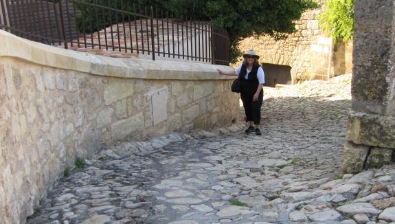
Flying into Bordeaux, we picked up our rental car, and entered the address of our hotel into the GPS. A couple of hours later, we arrived in Saint Émilion, at the North end of town, where the GPS told us to turn down an absolutely impossible street (too narrow and winding and steep for the car). After circling around the block a few times, we parked in the center of town and found the Tourist Office. The woman there informed us that our hotel was in the south part of town, and that it was impossible (despite the advice of the GPS) to drive through the town from the north part to the south part. She told us how to drive out of town and around to the south part, where we located our hotel. The next morning, we walked UP the street that the GPS had wanted to take us DOWN. While not drivable, it's perfectly walkable, although steep. See Margie walking up it in the picture just below, which doesn't clearly show the very sharp turn that would have been necessary to go down it in a car.
In researching GPS units, I've gotten the impression that TomTom units are a bit better in Europe, and Garmin better in the US (although this is rather a casual impression). Since most of our use is in the US, we've generally purchased from Garmin. But in using two different Garmin units in France, Italy, and Spain, we've found that it has sometimes turned us off onto some pretty dicey roads. I think that even small roads that are mapped in the US meet certain minimum standards. This doesn't seem to be the case in Europe. Frequently, we'd be on a main road that looped around a small hillside town, and upon entering the town, the GPS would tell us to turn. Suddenly, the road would tip down in a 25 percent grade, turn to dirt, and narrow to a couple of inches wider than the car. After a few hairy turns, we'd pop back out onto the main road at the bottom of the village. Sure, it had cut off some distance, but after a while we learned to ignore these suggestions and stay on the main road ("Recalculating!").
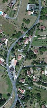
Why would the GPS tell us to bear right at that point? A better question is, why would it not? Obviously, the route to the right is shorter. But the GPS is programmed to calculate a route with the shortest time, not the shortest distance. If it knew that the local road to the right had a substantially lower speed limit than the main road to the left, it would have taken us to the left, staying on the main road. Thus I get the impression that the problem with its European maps is that it doesn't have enough information about relative speeds that can be traveled on different roads. Yet at times, the European maps seem to contain speed information that is often lacking from the US maps. At one point, the GPS beeped at me for exceeding the speed limit, and it often displayed the speed limit in the lower right corner of the screen. The Garmin GPS in Europe had a general tendency to take us on very small roads, if they were direct and cut off some distance. It took us over some roads that were so narrow, that they had stretches in which I couldn't imagine what I would do if a car appeared in the opposite direction. But in general, these small roads had very little traffic on them. Note 4 Once, heading for the town of Le Bugue, our GPS took us over a rather convoluted route, on scenic roads. This seemed a bit odd, since the most direct route, from the map, seemed to be the main road to Les Eyzies-de-Tayac. The route computed by the GPS was no doubt a tiny bit shorter in distance, but the twisty roads, I think, made it take substantially longer. This caused me to check the setting of the GPS to see if it might be set up to choose the route of shortest distance instead of shortest time. But it was indeed set up for shortest time. This was really the same issue we had encountered on the D704. Although the route was very scenic, we chose to come back the other way, repeatedly ignoring the instructions from the GPS unit ("Recalculating!" "Recalculating!"). From our experience on this trip, as on all our earlier trips, it's unwise to depend on a GPS alone. A general problem with any GPS is that you can become addicted to it, and lose track of the larger picture of where you are. Margie learned to follow along on a good conventional map of the area. There was another GPS problem in the countryside: many places didn't seem to have an actual address - that is, an actual street name and number. When phoning one of the local attractions, I asked for an address to put into my GPS. The woman said something like, "We're in the countryside - we don't have addresses." The result: there's nothing to put into the GPS as a destination. One restaurant we set out to find was Les Prés Gaillardou. We went to the trouble before leaving our apartment of looking up its web site, and then trying to locate it on the French "Mappy" site. But its address was only "Lieu dit Gaillardou, 24250 La Roque Gageac". "Lieu dit Gaillardou" just means "place called Gaillardou", which is pretty vague (and the restaurant didn't seem very concerned about this, since they didn't have detailed directions on their web site). We did find it, by the way, and had a nice meal there. You can see a picture of us at lunch on last week's blog entry, The French. On one occasion, trying to get to Les Jardins de l'Imaginaire, we drove into the town of Terrasson. There we hit a massive traffic jam, and it took half an hour to get out the other side of the town. Having missed our tour of the gardens, we changed our plans, and set off for the Chateau de Hautefort. Upon setting the GPS for Hautefort, it told us to turn around and drive back through Terrasson. Fat chance - we weren't going back through that mess. Consulting a map, we instead drove east a bit (the wrong direction), until we could go north to hook up to the A89. Jill bitched every step of the way, saying "Recalculating!" each time we ignored one of her suggested turnarounds. Only as we approached within a kilometer or so of the A89 did she decide that the highway was now the better route to Hautefort. After visiting the Chateau de Hautefort, we drove straight home on the D704, ignoring all pleadings to branch to the east for a slightly shorter route on dubious roads. Sorry, Jill - by then we had gotten very good at knowing when to ignore your advice. At the end of our trip, we spent a night in Bordeaux, to be able to catch our very early flight the next morning. I knew I would have trouble entering the All Seasons Bordeaux Aeroport hotel into the GPS, because the address was shown as "95 Avenue JF Kennedy". So just what do you type for the street name? Do you leave off the "Avenue"? I tried "JF Kennedy" both with and without the "Avenue", but in both cases got "Not found". I tried various other combinations of the JF with and without spaces. Finally, I just entered "Kennedy", and that did it, so apparently you need to just get a partial match. If you enter too much, it kills the match. When the street with a name matching "Kennedy" was finally displayed by the GPS, it showed the full name to be "Avenue du Président John Fitzgerald Kennedy" - that's what I would have had to have typed to get an exact match. The route circled Bordeaux, and the GPS took us straight to the Hotel. Like any tool, the GPS has its strengths and weaknesses, but overall we find it enormously useful in both the United States and Europe. And there's nobody inside that little box. Well, Jill, but only her voice.
  Note 1: Although I suspect that all my current readers are quite familiar with these devices, allow me to give a one paragraph description for the benefit of future readers. A standalone GPS generally attached to the windshield or dashboard of a car, in a position visible to the driver. Receiving signals from multiple satellites in low Earth orbit, it could calculate the car's position on the face of the earth to within tens of meters. It thus knew the car's latitude and longitude (and for that matter, its altitude). It also contained a roadmap, so it could place the car on a particular road. When given a destination (usually by specifying an address), it calculated a route to get there. As you drove, it continuously showed your position on a map on the device's screen. Most units also read out audible instructions, such as, "In 100 meters, turn left on Orchard Lane." [return to text] Note 2: Last evening, I took an informal poll among the members of my French discussion group, Le Cercle Français. Among those with a GPS, all but one had given it a name. The names assigned to the voice in the box were Esmeralda, Gypsy (or perhaps GPSy), Irene, Loretta, Mehitabel, and The Lady. [return to text] Note 3: The reading of street names (like "Orchard Lane") cannot be pre-recorded, as there are so many of them. They are created on the fly with computer-synthesized speech. Since the voice seems to match Jill's, it seems that the properties of her voice (the so-called "formant frequencies") are used by the synthesizer. Or perhaps she actually recorded the "phonemes" (the fundamental sonic constituents of speech) to be assembled by the synthesizer software. I don't know the details of how Garmin did it, but it sounds quite natural. By the way, she's not called "American Jill" out of an excess of patriotism. She's so identified to let users know that she speaks American English, and with an American accent. For ease of comprehension, users in the UK might prefer to select a speaker using British English. [return to text] Note 4:
Here's some speculation about a possible reason that a GPS unit might tend to take drivers off on small roads in Europe: in Europe, there's a greater variety of roads of various sizes that are all two-lane roads. In France, many of the "Departmental" roads (designated with a "D", like the "D704"), are quite good, with good shoulders and wide lanes, but they are still only two-lane roads. Perhaps the database used in the GPS doesn't distinguish, in terms of average speed, between a road like that and a much smaller (but still paved) road with narrow lanes and no shoulder. Perhaps the database considers these two types of two-lane roads to be equivalent. Then, of course, given a choice, it will go for the shorter of the two possibilities. [return to text]
 |

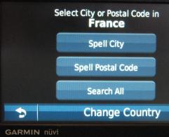
 I was thinking about these issues on our recent trip to the Dordogne region of France, for which we purchased a new Garmin Nüvi 1370T GPS. We chose it in part because it comes with maps of both North America and Europe pre-installed (see a part of its "Where to?" screen to the right).

 On our recent French trip, we hit the situation shown to the left, while driving north from Sarlat on the D704 (so we were on the main road, coming up from the bottom of the picture). When the road wiggled to the left, the GPS told us to keep right at the intersection. Now, it's obvious from the picture that the road to the right is a straight line, and hence shorter than following the main road which loops around to the left. But even without this overhead view (that I subsequently found on