This section discusses some of the things I've discovered as an American driving in France. French roads are not all that different from American roads, and most Americans should be able to comfortably drive in France. However, there are some differences that initially caused me problems. I hope these notes might help others have an easier time adapting.
Most of the text here was originally posted on the Fodor's Europe Forum, in various trip reports. Margie and I both post there under the screen name "justretired". When I first pulled this page together from various Fodor's threads, I posted a link to it on the Forum, and as a result, I got a lot of suggestions and information from the experienced travelers who post there. I'd like to thank Fodorites Alec, AnselmAdorne, Cowboy1968, hetismij, laverendrye, mpprh, and Surfergirl for their help. If you're interested in seeing the thread where this discussion took place, go to:
Disclaimer: These are just the personal observations of a few people, and this page is not intended to be a complete course on driving in France. I'm also not an expert on French rules of the road, and my observations could contain errors. You are responsible for learning the laws of any country you drive in.
Quick jumps to items further down on this page:
Seat belts: The Fodor's book Exploring France notes, "It is obligatory to wear these, in the back too, if they are fitted. If you are stopped by the police for not wearing them, you can be fined on the spot."
There are certain aspects of the signage that are taken for granted in France that might not be obvious to the foreigner.
There's a common sort of sign indicating a direction to somewhere, which is more or less a wide rectangle with a single name in it, which might be the name of a city or town (such as "Fontquentin"), or a place ("La Gare"). But a triangular projection on one side turns the shape into an arrow.
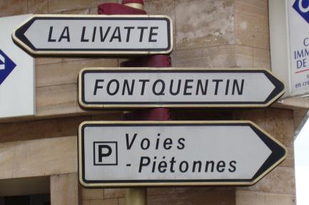
Let's see this sign in its context. You might be driving along towards Fontquentin, for example, and as you pass over a cross street, you see one of these to the left of the street you're on, on the far corner with the cross street. It says "Fontquentin", and it points to the right. You can see the above sign in the upper-left corner of the photo below:
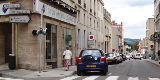
As an American driver, my impulse is to interpret this as "Turn right here for Fontquentin".
That is NOT what is intended. The sign is pointed to the entrance to the street right in front of you, and it means "Go straight here for Fontquentin". Sometimes the sign is angled slightly into that street, but basically, it points right. But don't TURN right, or you'll be on the wrong road.
Another quirk of signage: On a highway, you'll see a white sign indicating an exit to somewhere, let's say "Amplepuis", with an arrow pointing up and to the right to indicate the exit. Right under it is a blue sign containing one or more names, such as "Roanne". That sign has no arrows on it. I have interpreted this as specifying additional places served by this exit. This is not the case. The key is that the lower sign is blue. That color indicates "highway", so the signs mean "exit here for Amplepuis, but stay on the highway for Roanne".
France is dotted with ronds-points, which is the plural of rond-point, which means "traffic circle" in the US, or "roundabout" in the UK. For some reason, in my home state of Massachusetts, we say "rotary". I'm from New York, so the first time in Massachusetts that I saw a sign announcing a "rotary", I didn't know what they were talking about.
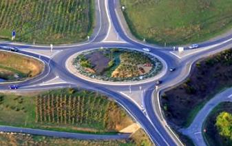
The rond-point has its advantages and disadvantages. A major advantage for the tourist is that you can keep going round and round. That may sound silly, but remember that the rond-point is an intersection, and as such will have lots of signs indicating which exit to take.
In a foreign country, the signs are hard to read. They are in a foreign language, and use unfamiliar conventions. It can be hard to make a snap decision as to whether an exit is correct, and if you take the wrong exit, it may take a while to reverse direction if you need to go back to re-read the signs.
But in a rond-point, if you have any doubt, don't get off. Just keep going around, reading all the signs until you are satisfied with your choice. It's great!
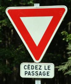
Furthermore, once you are in the rond-point, you have the right of way. Nobody will (or at least should) barge in on you. The rond-point is an exception to the general French rule of priorité à droite (priority to the right). Occasionally, some elderly Frenchman will forget this and barge right on in, remembering the old way of doing it (which killed lots of people), but that rarely happens these days. At every entrance, there's a "yield" symbol, a downward pointing triangle, and just in case you don't get it, there's a rectangular sign below it that says Cédez le passage ("yield the passage"), or sometimes, Vous n'avez pas la priorité ("you don't have priority"):
The disadvantage of the rond-point is that it jams up under heavy traffic, which we discovered in Boston, where we're getting rid of most of them. But I've seldom found that to be a problem in France, at least in the countryside.
Another reflection on driving in France: in the US, a highway generally stays a highway all along its length. But in France, it's common for decent highways to suddenly turn into a narrow road that goes right through the center of a village, only to become a highway again on the other side.
I was returning to the Ecole des Trois Ponts from the north one day, on the N7 (Route Nationale 7). At that time, the Ecole was located on the eastern edge of Roanne. So once I got onto the N7, which runs north-south to the east of Roanne, I figured I had no problem, as I knew my exit number. When I had come up from Lyon, I had exited the N7 at exit 66. So I relaxed my guard, following the N7 by following the signs towards Roanne. I thought I'd just ignore any exit for Roanne that wasn't exit 66.
Well, the N7 wandered through a few ronds-points, and I kept following the signs to Roanne. And where did I end up? Duh - Roanne! Roanne CENTER, that is, right in the city, well off the highway.
You see, I had to go past the bulk of Roanne to get to exit 66, and since I was following the signs to Roanne, and the N7 really ISN'T a highway north of exit 66, at some point I had deviated from the N7, and struck off towards Roanne centre.
My fault was to not carefully observe the REALLY SMALL square signs that said "N7", so as to stay on the "highway" (or what passed for a highway at that point). But even better would have been to follow the big signs to a destination further along the N7, such as Lyon, for instance. That would have kept me on the N7 until I saw my exit 66.
In the US, Route numbers are very prominently displayed, and directions are given by compass direction (North, South, East, and West). This is such a strong convention that driving the "Northeast Corridor" from Washington, DC towards Maine, where you are really going Northeast, the roads are nevertheless designated as going "North".
One of the most bizarre cases of this bias is right here in the Boston area, in the signs on the almost circular circumferential highway designated Massachusetts Route 128. On the entire length of this road, the clockwise direction is called "North", and the counter-clockwise direction is called "South". Never mind that south of Boston, if you're driving on Route 128 "North", you're actually going southwest. Coming up the Interstate Route 95 from Providence, Rhode Island, when you hit Route 128, if you turn toward the west, you're on Route 95 North, and if you turn toward the east on the same road, you're on Route 93 North.
Anyway, you won't see compass directions in France. Rather, look for the names of the major cities and towns along your route. As an example, when I was heading east toward the small village of Mazan, but was too far from it to actually see signs for Mazan (which is off the main road), I needed to look along the road on my map for a larger town, farther down the main road, and found Sault. I then followed signs toward Sault until I got close enough to Mazan for the Mazan signs to appear.
Quite often in France, roads go straight through the center of town. This can even happen on four-lane roads - they suddenly get smaller, the speed limit drops, and you find yourself going straight through a town. Pay attention.
In other cases, a road may go through a town, but bypass the center. If you're actually going to the center of that town, you need to watch carefully for another type of sign: the sign telling you you've entered a village. This is a rectangular sign containing a slightly smaller red rectangular border with the name of the town inside it. For example, a sign with a red border containing the word "Mazan" means you are entering the town of Mazan.
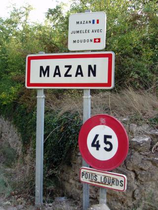
Why is this important? Because if you have been going to the center of Mazan by following the arrow signs pointing to Mazan, you will no longer see any more of them. Why should you? You can't go TO Mazan any longer, because you are already IN Mazan (that is, within the city limits of Mazan). So once you pass the red bordered sign which means "entering Mazan", you need to start following a different sign: "Centre Ville" ("city center"). That's one reason why it's so important to notice the "Entering Mazan" sign.
Some other reasons you need to notice these signs were pointed out by Fodor's posters hetismij and mpprh. First, when you enter a town, you are entering a zone with a default 50 Km/hr speed limit (unless otherwise posted). Second, by default your are entering a zone where the "Priority to the right" rule applies, unless this is contradicted by an adjacent yellow diamond "Priority Route" sign (there's a more detailed discussion of this a bit below). Major roads passing through small villages generally have priority, while smaller roads in smaller towns are still priority from the right (but it's the signage that informs you, not any such general rule).
By the way, here's what you see when leaving Mazan:
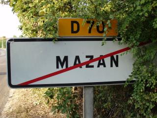
Seeing the town name with a line through it means you are no longer subject to a default 50 Km/hr speed limit, and in the absence of any other speed limit signs, you can resume highway speed.
Route numbers: these are useful, and they're on the map, but on the signs, they seem to be almost afterthoughts. They appear as small rectangular signs attached to larger signs. You can see one on the "Leaving Mazan" sign above. You need to pay close attention to notice them, so you might not want to count on spotting them quickly for making snap decisions at forks.
Another extremely common sign seen when leaving a town is the following:
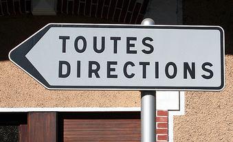
"Toutes directions" means "all directions". It points the way out of the town, and will lead you to other signs (often at a rond-point) indicating roads to various destinations. Of course, one could argue that it doesn't really point your way to all directions. It won't take you back into town, for instance. Follow it when you're leaving town.
On our 2009 trip to France, we kept seeing signs that looked like this, and we had no idea what they meant. I actually asked a French man in Paris, and he didn't know either (perhaps he didn't drive):
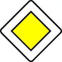
I was able to find it on the internet after my return. It indicates that you are on a "route prioritaire", which means "Priority Route". That means that on that road, you have priority over intersecting roads. These signs are repeated at frequent intervals along Priority Routes.
Another far more intuitive way of indicating this is with the following sign, which indicates that you have priority at the next intersection:

Why is this necessary? The usual rule in France is called Priorité à droite, or "Priority to the right". At an intersection, if there are no other indications, the right of way must be given to the car coming from the right. This means that if you are driving along a road, and a car is turning onto your road from a road entering from the right, you must yield to the entering vehicle, even though you're already on the road, and he is just turning on to it.
Obviously, this doesn't make sense if you are on a main road, and the intersecting road is a smaller or secondary road. That's why main roads are designated as "Priority Routes", and are marked with one of the two above signs.
As usual, the same sign with a diagonal line through it negates whatever the sign would indicate without the line. Thus, the following sign means "end of Priority Route":
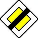
There's another way your priority can end: your priority ends when you enter a town (see above: a rectangular sign with a red border and the town name in the center). By default, that is the end of your Priority Route status, unless this is contradicted by an adjacent yellow diamond "Priority Route" sign.
I'm not sure I've fully understood all the French right of way rules. Particularly in towns, I sometimes found myself waiting for another driver who seemed to be waiting for me! Let me repeat my disclaimer from the start of this page: I'm not an expert on French rules of the road, and my observations could contain errors. You are responsible for learning the laws of any country you drive in.
Speaking of signs I didn't understand for a long time: the usual circular speed limit signs are often seen with the word "Rappel" under them:
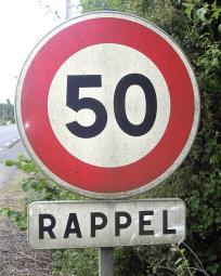
This was finally explained to me by Fodorites Surfergirl and Alec. "Rappel" in this context means "reminder". It indicates that the speed limit is (in the above case) 50 Km/hour, both before and after the sign (that is, this sign is just reminding you of the speed limit, and is not indicating any change in the speed limit).
OK, I can't resist a linguistic note: the verb appeler means "to call", as in je m'appel ... ("my name is", literally "I call myself ..."). Adding the "r" in front changes the verb to rappeler, literally "to recall" ("re-call"). The most common French way of saying "I remember" is je me rappel, meaning literally "I recall to myself". From the verb comes the noun rappel, which can refer to the recall of an ambassador, or a curtain call in the theater, or a reminder of something (the last being what it means on the speed limit signs).
Heading for a parking lot, a car right in front of us pulled out of a spot on the street, and we zipped right in. Hey, I thought, a free spot! There was no parking meter. But as we walked up the street, a sign caught my eye that contained the words "Stationnement payant", or words to that effect, so I looked around some more, and asked someone for advice.
It turned out I had to pay for my space, as with a parking meter, but the system is different from the most typical type of US parking meter, with a meter for every space. Rather, at intervals along the street are small machines called "horodateurs". You decide how much time you need, and read what it costs. Then you feed in coins (as for a parking meter, you'd better have them with you), and when the display gets up to the balance you want, you push a green button. The machine prints a ticket with a date and time of expiration on it, and you place it on the dash board in front of the steering wheel.
I've seen this system in the US as well. What's a bit tricky in France is that you may have to look some distance along the street to see the sign notifying you that the parking must be paid (and you need to be able to read it, of course). If in doubt, you might look on the dashboards of other parked cars to see if there are tickets there.
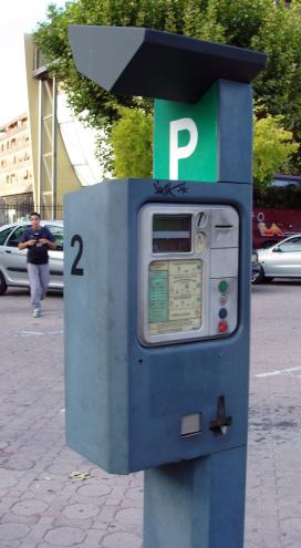
Then, it took me some time to locate the horodateur. It's not that large, and it's set on a post on the sidewalk. I had to ask for help finding it, and I had to walk about 30 meters (100 feet) from the car to the nearest one. The problem is looking for something when you don't know exactly what it looks like. Once you see one, it's easier to find the next. So here's a picture of a typical horodateur:
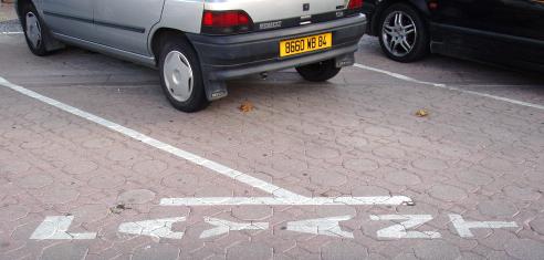
Another clue that you need to feed the horodateur can often be found written on the pavement: the word "PAYANT" stenciled on the ground:
My experience driving is mostly in small towns. Like New York City, with its extensive subway system, Paris with its extensive Métro is a city in which you're generally better off without a car, and I've never driven a car there. But Fodor's poster Kerouac, who lives in Paris, had this to add regarding the horodateur in Paris:
"The horodateurs for parking in the city of Paris do not take coins. They were being pillaged too much, so now they only take special chip parking cards (sold in a tabac) and Moneo electronic minor payment cards. NONE of them take coins, which is a big problem for tourists, because the parking cards on sale often have a much greater value than a visitor is planning on using (even the people from the suburbs of Paris feel they are being ransomed for this). The only solution that I can offer for this particular problem is never to park on the street in Paris and only use the underground lots. For anybody with a "disabled" parking card, it is also good to know in Paris that parking is free in both the disabled and the normal surface spots for anyone displaying the card. I don't know about other French cities for this."
Palenque asked if parking is free in Paris in August, to which Kerouac replied, "... it is still free on SOME streets. You have to look at your friendly local horadateur to know if it is free or not. On the ones in Paris, there is a little zone at the bottom, outlined in green, if I recall it correctly, that says when things are free (in French only). At worst, this would be dimanches et jours fériés (Sundays and holidays), sometimes samedi (Saturday) is added, and of course if you are lucky in the summer, you will find the word août (August) also on the list."
We've now taken our Garmin Nüvi 650 GPS unit on two separate vacation trips, one in Italy, and one in France. The European maps which we purchased from Garmin ($150) are delivered on an SD card that plugs into the unit. The GPS was very useful, but it had some quirks. On the Italian trip, we immediately found out that the English pronunciation of the Italian street names made that name-reading feature almost useless. I know that TomTom GPS units can pronounce street names properly in French, and probably Italian, while still giving the driving directions in English. But with my Garmin Nüvi 650, the language of the directions and the language of the text-to-speech reading of the street names cannot be separately selected - they're either both in English or both in the local language.
Reading Italian or French street names using an English text-to-speech algorithm really mangles them badly, often beyond comprehension. For example, lots of Italian road names start out with "Strada Provinciale" (Provincial Road), followed by the actual name. "Provinciale" is properly pronounced something like /pro-vinn-CHA-lay/. By the time the Garmin unit got past /STRA-da pro-vinn-see-YALE/, I usually couldn't understand the rest. Fortunately, I could read the street name on the display, and proper pronunciation of street names, while helpful, is not a critical part of the operation of a GPS.
In France, I tried to fix the street name problem by switching the unit entirely to French. As a result, the street names were better, but of course it became harder to understand the directions. We only kept the GPS in this mode for a little while, then decided that reacting rapidly to the directions was more important than having the street names pronounced properly. There were two setting changes we always DO make in Europe: we reset the time zone, and we change the distance unit from miles to kilometers (to correspond to all the signs). The latter also causes the unit to read out shorter distances in meters instead of feet.
The Garmin unit, particularly in Italy, had another quirk: it turned us off onto some pretty dicey roads. I think that even small roads that are mapped in the US meet certain minimum standards. This doesn't seem to be the case in Italy. Once, we were on a main road that looped around a small hillside town, and upon entering the town, the GPS told us to turn. Suddenly, the road tipped down in a 25% grade, turned to dirt, and narrowed to a couple of inches wider than the car. After a few hairy turns, we popped back out onto the main road at the bottom of the village. Sure, it had cut off some distance, but after that we learned to ignore these suggestions and stay on the main road.
On both trips, the GPS unit would occasionally become confused. In Italy, on a trip from Montepulciano to Montefollonico, it seemed to get really confused at the intersection of the N146 and the N137. Judging by its behavior, it seemed to think we couldn't make any turns there. We were smart enough to ignore its advice, since after all there was a large sign with an arrow that said "Montefollonico". Once we'd made the turn, the GPS recomputed the route, and picked up as if nothing odd had happened.
A year later, in Languedoc, France, the Garmin unit seemed to have frequent problems with the roads not matching the maps. It was clear that there has been a lot of construction in the area recently - many of the roads and roundabouts looked new, and were not known to the GPS. In one area, the road had been substantially shifted, and you could see the old road off to the side, now being used for parking. The image on the GPS screen showed that it thought we were plunging along through the dunes. I had to mute it to stop listening to its exhortations to get back on the road.
I have several other examples of the GPS getting confused. On our first use of it in France, to get to our B&B, it didn't accept the street name of our destination (it didn't seem to know that name). We simply entered the name of another nearby street, taken from an area map I had printed from Mappy before departure.
We set up the B&B location as "Home", by telling it to "use this location as home" while the car was standing in the driveway. The first time we arrived back at our new "home" street, I expected the GPS to announce out loud, "Turn right on Rue Marcellin Albert". Instead, it told us to "Turn right on road". So although it apparently had the street on its internal map, the GPS unit didn't seem to know the street's name. We also found out that it didn't know that the street is one-way - it always told us to make an illegal left out of the driveway. When using a GPS, one has to learn when to ignore it.
One more problem: In France, we took a long drive from Montblanc (Herault) to Collioure, almost on the Spanish border. But it was made longer by the fact that the GPS, to get to the A9, turned us off the D18 onto the D125 to Bessan, and then tried to take us over a few gravel roads, all of which disappeared into private property. We had to revert to a regular map to get to the highway, which was a little tricky, because the GPS had left us in the middle of nowhere. Oddly, it didn't try any of this nonsense on the way back home, even though it was essentially the same route in reverse.
We found ourselves often going to visit a town in which we had no specific address, and it's hard to give the GPS a destination in that case. Sometimes, we could look at information we had on the town, and pick out a random address - a restaurant or a shop. But on my Garmin unit, I also found I could just "browse the map". That is, I'd touch the map, which would convert it from a perspective view to a standard map seen from above. I could then use the "minus" key to zoom out, and slide the map around with my finger, until I found my destination. Zooming back in if need be, I could select a destination just by touching it, and then select "Go".
When I list all the assorted problems we had with the GPS unit, it almost seems that it was not worth having along. But that's not the case at all. I actually love my GPS, and find it particularly useful in Europe. The problems listed above comprise just about everything that went wrong with the GPS in a total of five weeks of travel in two countries. Most of the time, it worked fine, and allowed us to drive from place to place error-free. Indeed, a general problem with any GPS is that you can become addicted to it, and lose track of the larger picture of where you are. It's a good idea to also have a good conventional map of the area, and while I drove, Margie often followed along on the map, to know where we were in case of a problem.
On one trip from Les Gorges du Tarn to Arles, we wanted to have lunch on the way at the Auberge de Saint-Hilaire, just outside of Alès. We picked it out of the green Michelin guide, and telephoned to be sure it was open for lunch. When I asked for directions, I was asked whether I perhaps had a GPS unit in my car. When I responded in the affirmative, I was told to enter the address "5 rue André Schenk" into the GPS - an address not given in the guide. This was a very effective way of taking us to the restaurant - I don't think we could have easily found it otherwise.
The first time I used my GPS back in the US after returning from France, it spent several minutes trying to locate the satellites, apparently without success. It then asked me whether I was indoors (I answered "no"), and then, whether I had moved more than about 100 Km since last using the unit (I said "yes"). It then thought for a bit longer, finally realizing that I was on an entirely different continent. I also had to reset the time zone again, change the distance unit from kilometers back to miles, and reset my "home" location.
By the way, for you Garmin users, resetting the "home" location is a bit tricky (at least, on my Nüvi 650 with two-year-old software). It was not obvious to me how to do it from browsing the menus - I had to actually read the manual (gasp!). You have to select "Where to?", then from among the various ways of entering a destination, select "Favorites". Then select "HOME", then "Edit", and then "Delete". Having thus deleted your previous "HOME" specification, you go back to "Where to?", and select "Go Home". Finally, it will tell you that "HOME" is not set up, and will offer you various ways of specifying it (by address, "use this location", etc.).
... or go to my home page
This page was last updated October 29, 2009