Bob Briere, president of the Sturbridge Historical Society, led a small group on a visit to the site of the former Camp Robinson Crusoe ("CRC"), in Sturbridge, Massachusetts. The land has been purchased by the Town of Sturbridge, and the buildings, which are collapsing, are slated to be demolished.
You might want to compare the state of the camp now, July, 2006, with the photos Bob Handloff took just before the 1999 Camp Taconic reunion, seven years ago. Those can be seen by clicking here.
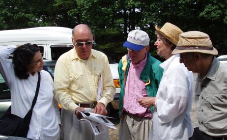
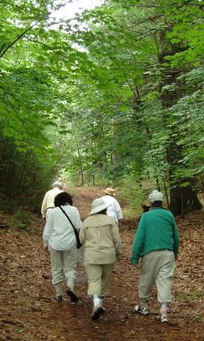
Those taking the July 6 tour are shown just below. Left to right, they are: former camper Phyllis (Krakauer) Jeswald, Bob Briere, and former campers John Baker, Leslie Kandell, and myself (Larry Krakauer). My wife Margret Krakauer, who did not attend the camp, also came along, but is not shown in the picture (she took it, actually).
Although we walked around the grounds, itĺs not safe to enter any of the collapsing buildings.
Former camper Bob Handloff contracted Lyme Disease on a previous walk-through on May 27, 2006 (it was successfully treated), and had warned us of the risk of ticks. Those on this tour thus wore light clothing (the better to spot pin-head sized deer ticks). Most of us pulled our white socks up over our pants legs, and taped them to our pants with duct tape (we looked very chic). We also sprayed ourselves liberally with insect repellent (so we smelled good, too).
I took all the pictures on this page, except as noted.
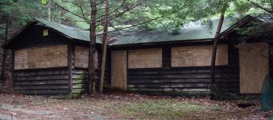
We walked in on a path parallel to the lakes, starting at a bend on Old Sturbridge Village Road, north of Shattuck Road (click here for a satellite view of the camp). We arrived at the old office, which is boarded up:
In my later years at the camp, as a "Trainee" or "Forrester" (two stages of Counselor-in-training), I recall working at the office, placing long-distance calls for the campers. This was done by dialing "O", for "Operator", and telling the operator, "Iĺd like to place a long-distance call to New York City, Manhattan, BUtterfield 8, 1234. Please call me back with the charges." There were no area codes, and no direct dialing. Youĺd sometimes hear the local operator call a special long-distance operator to obtain a coded "routing" for the call, and the connections had a rather hollow sound.
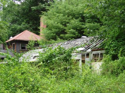
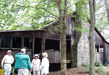
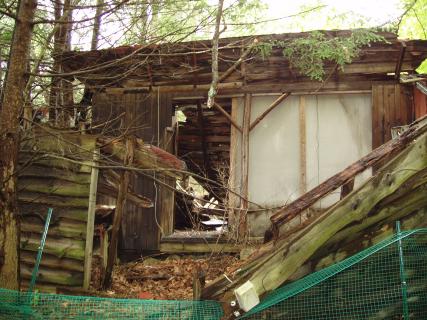
From the office, itĺs a short distance (shorter than we remembered) to the main house and dining hall. The dining hall, which started as a greenhouse, is quite broken up and overgrown:
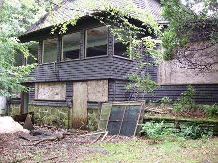
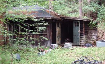
The two-story main house is in better shape, but still collapsing, as are all the buildings. The former campers all remembered taking showers under the main building:
A left turn, and up the hill to "Hill Camp". Old asphalt paving has kept the road from being overgrown. When we were campers, there were multiple bunk buildings on both sides of the road, but these seem to have been mostly removed. In the photo, notice the duct tape around our ankles, to guard against ticks:
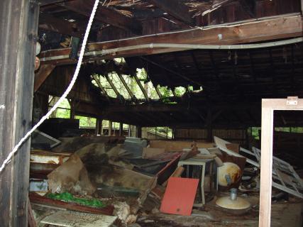
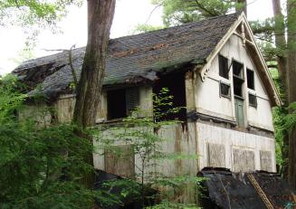
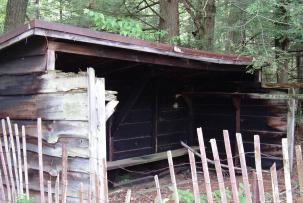
The "Rec Hall" remains at the top of the hill, although itĺs falling apart:
The dilapidated interior of the Rec Hall could be seen through the door. Apparently, during the time they owned the land, Old Sturbridge Village used it for storage:
The ex-campers recalled the various dramatic productions they had starred or participated in. Dramatic skits and plays were an important part of my own experience at the camp. As a younger camper, I used to put on improvisational skits with Bobby Brown. Bobbyĺs brother Jon Brown can be seen in a "Bust-up" skit on my web page, entitled "Jon Brown gets a Shave and a Haircut (2 bits)" (it can be seen by clicking on that link). Click on the next link to see other photos from the Super-Senior Girlsĺ production of "Kiss Me, Kate". These were taken back in the days when the Rec Hall didnĺt have holes in the roof, and trees growing on top.
Back down the hill, we made a left turn down towards the lake. Towards the right along the path, the "Common" area, once an open lawn, is now completely overgrown with 35-year-old trees. Ex-campers may recall the large circular gong which hung there, which must have been about four feet in diameter (it is no longer there). It was rung to signal the start and end of various periods of the day (swims, meals, and so on), and could be heard all around the main camp grounds. There was also a public address system, but unless there was some emergency, it had only one purpose: when the camp went on a so-called "Rainy Day Schedule", this was signaled in the morning by the playing, over the loudspeakers, of a scratchy recording of "The Muskrat Ramble".
We arrived at Bunk Two. Joshua Hill, camp founder Josh Lieberman's grandson, informs me that, "The hidden compartment under the steps was part of the underground railway, a hiding place for fugitive slaves." Note, though, that the front steps have already collapsed, and have been removed.
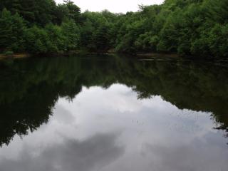
Making a left turn at Bunk Two, we strolled south (upstream) along the "Boating Lake". A basketball hoop sat in the woods among the trees on the left:
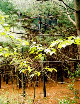
Photo 5/27/06, Robert Handloff
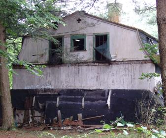
This was followed by the chain-link fence that surrounded the tennis courts. The fence is in remarkably good shape, but the trees inside and outside the fence are about the same size. The roof of the "Nature Lab" is sagging, but some of the rough pine siding was in decent shape.
The ball fields, and the field beyond on which we used to play Capture the Flag and Klondike Gold Rush, are now mostly submerged, apparently due to the removal of some gravel, followed by a blockage of the stream. Itĺs hard to make out the outline of the original field when standing alongside it. Joshua Hill said, "I believe that lake on the athletic field was created by Old Sturbridge Village as part of their abortive plans for a mill village." Here's what the ballfields look like now:
We reversed direction, and headed north, back past Bunk Two to Bunk One:
The photo below shows the boating lake, seen from near Bunk One. I recalled many hours of boating on the lake, either canoeing or sailing:
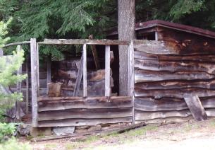
We proceeded to the dam, and the remains of the old Shop building. Phyllis recalled working on a pottery wheel from which you could look out over the lake as you worked. This is a view of the shop building from the side:
Not far away, the old "Canteen". We all remembered that a vending machine there sold the old hourglass-shaped heavy green-glass bottles of Coke, now called "classic Coke". Thatĺs also where we went for haircuts, for which a barber would be brought in from Sturbridge:
Going down the path to the swimming beach, we found portions of the changing rooms still standing. In some ways, they have fared better than the other buildings, because they are mostly walls (thereĺs no large roof to collapse). The boys' changing area:
The girls' changing area:
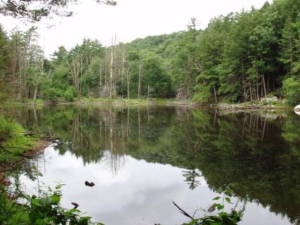
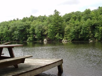
One difference in the view from the beach: "Loverĺs Leap". This once notable rocky outcropping can no longer be seen. It obviously must still be there, but evidently the trees in front of it have grown so much taller that it is obstructed from view. Only one dock remains at the swimming lake:
We continued on to the "Primitive" area, going around the east side of the lake, so the lake was on our left (back in our camp days, we usually passed the lake on the other side). You may recall it as a small, circular lake, with an island in it. A concrete section of the otherwise dirt road dipped down at a sharp angle, followed by a flat section at the bottom, and then a symmetrical climb up the other side.
This section of the road, the bottom of which was several feet above the level of the lake, was an emergency overflow, intended to protect the dam. Being concrete, it would allow flood waters to overflow without eroding a hole in the earthen dam. But under normal conditions, it was dry, and we used the road all the time. Water from the lake flowed out through a large pipe under the road, to the west of the emergency overflow. Thus, I was startled to see that this "overflow" is now the main outflow path from the lake:
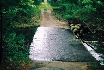
Photo 5/27/06, Robert Handloff
Evidently, the original outflow pipe has become blocked. Bob Briere didnĺt even seem to know of its existence, and seemed to have assumed that the lake always flowed out over the concrete overflow. Since the overflow is now the outflow path, the lakeĺs level is higher than it was originally, so the Primitive lake is larger. But it has also silted in a bit, so the island is no longer an island. The "island" has joined the mainland on the south side, leaving a larger, crescent-shaped lake.
I couldnĺt look for the original outflow location, because that would have meant wading across the current spillway to try to find it, and there was a substantial current. An alternative would have been to walk around the south side of the lake to get to the other side (that is, to walk completely around the lake), but it was time to leave.
Note added 4/14/09: The old weir and outflow pipe do not seem to be clogged - apparently some boards were added to the weir deliberately, to raise the level of the lake. I'm not sure why anyone would want the lake to flow out over the road - perhaps they want to discourage access by foot. In addition, although the island has gotten larger, with the addition of a great deal of silt, the incoming stream still does flow around both sides of it. Therefore, it is still an island, even though that is hard to see in the satellite view. The stream flows into both tips of the crescent.
The entrance to Squantum Primitive was completely grown over, and with the tick hazard, I didnĺt try to plow through the brush. No buildings or tent platforms were in evidence in the Primitive area, although perhaps I would have found remnants had I bushwhacked my way into the woods. In any event, arrival at Squantum Primitive brought us back to close to our starting location ľ out through the gate onto Old Sturbridge Village Road. Iĺd love to come back some time and try to find remnants of the Primitive sites (Squantum and Trout Pond), the open sided Primitive Rec Hall, and so on.
My wife Margie, who was not a camper at CRC, was impressed by how large the camp was. Most other summer camps weĺve seen have been physically smaller (recall Camp Taconic, where we had the ĺ99 reunion). But the ex-campers all had the opposite reaction: we were surprised by how close things were. This may have been due to the lack of open space caused by everything being overgrown. But of course, the obvious reason is that as campers, we were ourselves smaller, so all the walks seemed longer to us.
It was interesting to me how many detailed memories came back after so many years, particularly when they were reinforced by being part of a group of people. Our collective memory was better than any of our individual memories, particularly as we recalled what the various buildings were. For instance, does anyone remember the building up above the canteen, where the cooks lived?
I was glad to be able to take this tour of the camp, a final visit to the place where I spent so many happy summer months. Although itĺs sad to see the buildings in such disrepair, everything must come to an end, and the memories brought up were good ones. The buildings are slated for demolition, but the land will eventually begin to be used again, as a recreation area for the Town of Sturbridge. Once again, the shouts of happy children will ring out on the camp grounds. Our thanks go to the Town of Sturbridge for their substantial investment in preserving this land. It's hard to think of a better use for it.
My thanks to Bob Briere for having arranged the visit, and for taking us around. The campers and camp staff always appreciated what the Town of Sturbridge had to offer us - not only Old Sturbridge Village, but also restaurants, stores, community theater, and so on. I hope that with projects like "Planting Weekend", CRC campers can give something back to the Town.
This page was last substantially updated April 14, 2009.
Some broken links were fixed February 29, 2020