The Hamant Brook Restoration Project is a proposal by the Massachusetts Division of Fisheries and Wildlife to approximately restore the original state of the Hamant Brook, as it was before the building of the dams that created the Camp Robinson Crusoe lakes. On April 11, 2009, I attended a public walk-through of the old camp land, sponsored by the Town of Sturbridge Public Lands Advisory Committee ("PLAC"). Representatives were also present from the Massachusetts Division of Fisheries and Wildlife, and Sturbridge's Conservation and Finance Commissions. The PLAC announcement from Richard LaFranchise, the committee chairman, noted, "During this time everyone can view the land as is with ponds and dams, and [consider] what it may look like should the Hamant Brook Restoration project move forward."
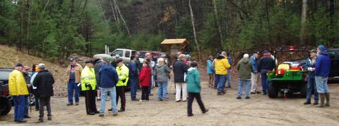
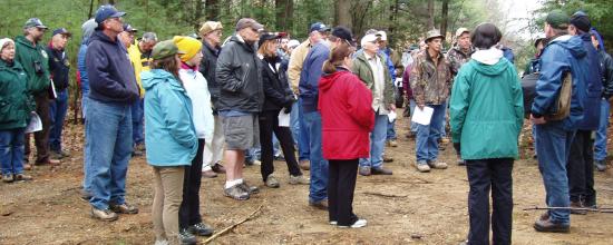
I met Sturbridge Town Historian Bob Briere at the Publick House at 8:15 AM on Saturday, April 11. Bob has been a Sturbridge presence who is always keeping an eye out for the interests of the ex-campers. He is opposed to removal of the lakes. We then we drove down to the walk-through a bit before 9:00. I was surprised at the large crowd that turned up on a rainy, chilly Saturday morning:
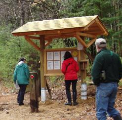
The Town has built an information kiosk at the entrance to the site:
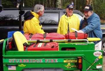
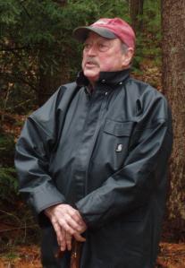
Below, Bob Briere (center) behind a fire department all-terrain vehicle ("ATV") that accompanied the tour. It was donated to the Town by John Deere. The police department sent three officers, and also brought another ATV, which they used to transport some attendees who might have had difficulty completing the entire walk.
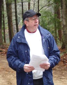
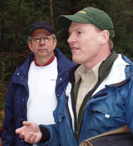
Dick LaFranchise (left), chairman of the Public Lands Advisory Committee, welcomed the walkers. David Barnicle (right), chairman of the Sturbridge Conservation Commission, also spoke:
Todd Richards, a Fisheries Biologist from the Division of Fisheries and Wildlife, was introduced. He handed out some copies of the Hamant Brook Restoration proposal during his initial remarks. During the course of the walk, he presented the Commonwealth's case for the restoration, explaining at each point what the effects would be.
A .pdf of the proposal can be found here, but CAUTION! it is 4.5 Mbytes in size, contains lots of large images, and opens very slowly, even if you have a fast connection.
The walk began at the the entrance just to the east of the Primitive lake (the northern-most lake). This portion of the old camp land is actually still owned by Old Sturbridge Village - it was not included in the transfer to the Town of Sturbridge. This lake flows out through a weir that feeds a culvert under the dam. However, the boards in the weir, for some reason, are kept high enough so that the water also flows out over the concrete dip in the road. Although I'll sometimes refer to this as the "spillway", it was only intended as an emergency overflow from the lake. When the camp was open, it was kept dry (by keeping the lake lower). The only time I ever saw water running over this spillway when the camp was open was during the flood of 1955, when the volume of water overwhelmed the culvert.
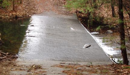
This time, I wore waterproof boots, so even with the heavy flow of water, I was later able to walk over the spillway. Despite its mossy appearance, the stone surface is so rough that it is not too slippery to carefully walk over.
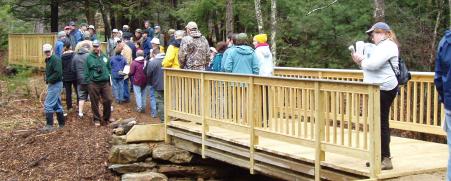
Walking south following the Hamant Brook upstream, the brook splits in two where it enters the Primitive lake (so that the body of land that gives the lake its crescent shape is still technically an island). These two branches of the brook have now been crossed by a pair of new bridges. These were designed and built over the summer of 2008 by students at the Technical Division of the Tantasqua Regional High School, in cooperation with the Conservation Commission and the Community Preservation Committee, with the Sturbridge DPW assisting with the installation. The Town of Sturbridge provided $20,000 for materials, from Community Preservation Act ("CPA") undesignated funds (approved at the Special Town Meeting of April 28, 2008). The bridges can be seen below:
We continued downstream, and arrived at the "swimming lake". Even the sandy beach is becoming overgrown, and for some reason, the lake is being kept at a rather low level (it is probably a couple of feet below its "normal" height).
Continuing towards the main camp, we paused at the old outdoor amphitheater overlooking the swimming lake, just a little north of the shop by the dam. I was introduced to the gathering as an ex-camper, and explained that from time to time, dramatic presentations occurred on that site. The logs that were used for seating are gone, and the "stage" is somewhat overgrown. The only real indication of what was there are some boards nailed high up in the trees, that once supported outdoor spotlights.
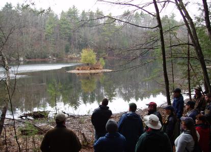
The photo below shows some of the group looking out over the lake from the amphitheater. The low level of the lake can be clearly seen. The gravel portion of the small island would normally be submerged, and the bare land showing in front of the people would normally be under water:
I'm sad to report that I have no pictures beyond this point, as my camera broke. We walked up to the site of the former shop, now gone, as are all the buildings. The group paused on that site, and there were some lively discussions between proponents and opponents of removing the dams and restoring the brook. We then continued along the "boating" lake, with the sites of the bunks and nature lab marked by patches of wood chips where the buildings used to be.
Then on to the old ballfields, now flooded. In my earlier reports, I thought that this flooding was due to a blockage in the brook. Actually, it turns out the the former fields are flooded because they were mined for gravel. They've been dug so deep that these "fields" now contain the deepest of the lakes. This lake will remain even if the brook is restored (I think the only alternative would be to completely refill it with gravel). By the way, the brook does not flow through this lake; rather the brook flows around it, to the west side.
Finally, we walked around the ballfield lake to the south, to see the brook where it enters the camp property. It was flowing quite vigorously, as it's Spring, and there's been a lot of rain recently. This was the end of the formal tour. With all the discussions along the route, it lasted until around 11:00 AM.
Returning, I went over the newly constructed bridges, and walked around the west edge of the Primitive lake with Bob Briere and Louis Berthiaume, to look once again for any remnants of the Primitive units. Louis said that considerable excavation has been done to the west of that lake, and I think that destroyed any trace of the "Trout Pond" unit. For the first time on my several visits, I got all the way around to the north side of the lake, and found what appeared to be some remnants of the bunks that were once there (that housed the Trainees and Foresters). We walked through the woods looking for remnants of the Primitive Rec Hall, but couldn't find it. We walked (carefully) over the spillway, and I again went through the woods looking for remnants of Squantum primitive, but apart from one slab of concrete of uncertain origin, I found nothing.
Subsequent to the event, Bob Briere sent me a copy of an article on the walkthrough in the Southbridge Evening News, Monday, April 13, 2009. The article and the photographs were by News staff writer Christopher Tanguay, who attended the walkthrough, took photos, and interviewed assorted attendees. The article includes a photo of Bob Briere addressing the crowd. It also mentions my presence on the tour, and notes that we are planning a reunion of former campers. I'm quoted as saying, "We'd love to be able to do something on the land ... It's not ours anymore, but it's wonderful that it's going to be used for recreation."
It was particularly interesting to me to witness the lively debate going on in the Town of Sturbridge regarding the future of the old camp site. There are disadvantages to the traditional New England Open Town Meeting form of government that is found in Sturbridge (as well as in my own town of Wayland). But one of the many advantages is that it promotes a great deal of interest in governmental decision making among the townspeople. In an Open Town Meeting, any town resident who shows up is a member of the legislature, which promotes the idea that everybody is personally responsible for the decision making of the Town. In any event, I was glad to see so many people interested enough to show up for the tour.
Whatever the ultimate disposition of the lakes and the Hamant Brook, I think ex-campers will be happy to know that the site will be used by a great many people for a large variety of recreational purposes. I think that the camp's founders Josh and Leah would have been happy about this as well.